The Northeastern Quadrant – First Foray
A couple of weeks ago I planned a journey to Cottonwood Falls, Kansas. The Saturday of the planned flight was zapped, though, due to heavy rain. So, the Adventure was postponed in expectation of a more favorable clime. I had the trip mapped out and had called the airport manager to get the fuel situation. I use AirNav.com to get my airport info and it had informed me there was no gas on the field. I called Charlie Klamm who was listed as Airport Manager. He was very helpful and happy that I was planing to come to their fair city. Since I had a satellite map open on my computer while talking to him, he was able to give me the position of the gas station in town even though Google Earth did not show the road names. Cottonwood Falls Airport is unique (at least for me so far) in that the North end of the North/South Runway directly abuts the South side of town. Later I will show you pictures of it but suffice to say, it is a pleasant, easy stroll from the tiedown area to the center of town. There is lots to see and do there.
Rationale Redux
In an earlier post I described how I had not yet explored the “Northeast Quadrant” of my flight area. My “long distance” Fun Flight GOPs (General Operating Principles) dictate a daybreak flight into the prevailing wind (which, that early in the morning, I can avoid by hugging the earth). This then allows me to “ride the wind” on my return trip when the wind usually has increased in velocity. Also by then the wind will have reached down to the surface of the Earth so the “earth hugging” headwind avoidance trick will not work then. It’s like saving desert until the end of the meal. Delayed gratification, dig? The Practical Aspect of it insures against the possibility of fuel starvation prior to attaining the destination. And, you know if you can make an outbound destination when fighting even a light headwind, you know that same (re-filled) fuel tank will get you homebound riding an even bigger tailwind.
All this leads to the point that the prevailing winds now that Autumn has arrived are from the Northeast. So it will be interesting to explore that region for a while.

Red Sky At Morning – Sky Surfer Take Warning – NOT
The weather forecast reliability was A-1 just as they said it would be. The air was very humid and a bit chilly so I assembled my Stage 2 Cold Weather Attire. This includes my Sears insulated coveralls, a “gaiter” for my neck, a sweater and my electrically heated gloves. That was sufficient for the morning flight but a bit too hot for the afternoon trip back. Even though the “morning sky was red”, the old saying did not hold. It turned out to be a great day.

Note Dew Trails on the Grass
The high humidity of the morning limited visibility to a considerable degree for about the first hour of the flight.

1,000′ AGL Looking Southeast at Mulvane, Kansas

After crossing South of Derby, Kansas I headed Northeast. Northwest of Augusta Airport is the private airfield shown above. I believe it is called Daniel’s Landing. I have heard a T-6 is hangared there but, if so, I have not seen it on the field yet.

More Trees Than Expected
In the area North of Augusta Airport are a lot of “suburban farms”. Some of them are raising animals but most of them are homes with 5 to 50 acres of land upon which they keep horses. Because of this I had to hold more altitude than I would normally like to on this leg of the flight in order to avoid spooking animals. This caused me a significant deficit in ground speed for about the first 40 minutes of the flight. Until I reached the area shown above I was averaging about 26 mph ground speed. Once I entered this area, though, I dropped down to Ultralight Flight Level 75 and my ground speed built up to a steady 40 mph. The significantly forested areas you can see in the photo caused me to weave left and right to stay over open fields, though. When flying low I do not cross over any forested area in case I have an engine problem and have to “put ‘er down“.

Attractive Red Roofs
The farm shown above was directly in my route. So, after taking the shot I veered to the East in order to not spook the cattle and horses they had penned in the foreground.

An Abandoned, Full Size Silo with a Tree Growing Up Through It
Gateway to the North End of The Majestic Flint Hills of Kansas

Cattle Trails Lead to a Dry Windmill-Fed Pond

A Lone Cell Tower In The Company Of The One Farm For Many Miles
As I approached the area West of El Dorado, Kansas, the trees thinned out dramatically. The ground was carpeted in wild flowers. Mostly Goldenrod here.

Beautiful Rolling Hills

More…

Horizon to Horizon…

A Prairie Picture of Simple Beauty
The next four shots are linked. Just as I saw the gently sloping, rolling hills shown first below, I looked to my left and beheld the building on the hill. The rather large “house” was uninhabited and I think it is probably a hunting lodge, although I could find no mention of it on the web. I decided the scene was worth some extra effort and expended some fuel maneuvering to get the shots presented below. Truly a wonderful place.

Looking North from 200′ AGL.

This lodge faces the previous scene.
I didn’t get any closer in case people were sleeping but I don’t think anyone was around that day.

Lodge Under The Wing

Landscape Directly North of the Lodge
After about 20 minutes of flying I saw another settlement alone on The Prairie. It is of the modern log cabin design and looked fairly new.

A Log Cabin by its Lonesome
Then about another 10 minutes later I spied this handsome edifice about a half mile East of my position. I made a gentle curve over to the front of it so you could see how nice it looks. A log cabin, too, I suspect this is a vacation or hunting lodge.

Log Cabins Galore

Cattle Graze in the Distance

Another Castle of the Flint Hills

Endless Beauty
For two hours I had the priviledge of floating above the awesome beauty of the Kansas Flint Hills. I hope some of the pictures above give you some sense of the great dignity of this land. I could have continued in my dreamstate indefinitely but my MXL did not share the same enthusiasm. It was thirsty for what the English call petrol. The maximum flight time I have been able to achieve with my Quicksilver thus far has been 2 hours and 25 minutes. With the forward speed loss due to the headwind early in the flight, I was looking up at a fuel tank that was more empty than full. Flying low through these rolling hills can hide a town easier than you might think. My lightning fast mind told me that I should be seeing Cottonwood Falls but at 2 hours and 15 minutes of flying, it was nowhere in sight. I burned an extra thimble full or two of gas to gain a hundred feet of altitude and – sure enough – a town manifested in the distance. Below you can see what I saw.
Cottonwood Falls

Cottonwood Falls, Kansas from 150′ AGL Looking Northwest
Again my not-so-trusty GPS had led me a few miles astray my destination. But, it was no big deal because I had kept track of the time en route. I knew Cottonwood Springs was hiding around somewhere in these rolling hills and would not escape my (used to be) eagle eyes. As I came closer to town I scanned for air traffic and for the airport itself. I saw neither for a while. As I approached the town I shot the picture below. I would have thrown it out but I liked the way the buzzard looked in the foreground. Looking it up, I was scolded by “The Web” for calling it A Buzzard. The proper name is Turkey Vulture. No matter what you call them they are Flyers of the First Order. Along with Red Tail Hawks, they are my favorite birds to watch as I fly this region. I really appreciate The Turkey Vulture’s minimalist approach to flying. They barely move a feather as they soar above the earth catching the faintest of thermal lift, using it to their advantage. In my own way I try to emulate this flying style.

A Buzzard Swings Low to Check Out Something That Smells Bad – A Good Thing From Their Perspective…
Finally I saw Cottonwood Falls Airport – lush and green like a golf course. I keep forgetting this but when I use Google Earth to look at prospective landing fields, the color is almost always wrong. The GoogEarth shot of Cottonwood Falls was probably taken in the dead of Winter. This made the field stand out like a big dark patch on the ground and that is what I was searching for. On this fine autumn morning the landing field blended in with all the other green hues of the area. Golf courses usually don’t have windsocks, though, and when I saw “the sock”, I knew I was on target.

Downwind at Cottonwood Falls Airport (Note the earth-sheltered home at the end of the runway)

Turning Base for Final Approach (again Note the earth-sheltered home and hangar)
Kevin and Sammy-Joe
As I came in for landing I noticed a guy playing catch with his dog at the hangar at the South end of the airfield shown above. After landing, I taxied to some well-kept tiedowns and proceeded to affix my craft to the ground so it would be there when I got back from walking around town. It was close to 11 am and the wind was starting to build up on the surface. As forecast, it was right out of the Northeast and would provide an excellent tailwind when heading for home. As I tied the last rope, a pickup rolled up and a big yellow labrador bounded out of the cab. Kevin Carrier came out of the truck also and introduced himself. He and his dog Sammy-Joe (Samantha Joe when she’s in trouble…) were the ones playing catch at the end of the runway. He owns the choice property at the end of the runway. Kevin was born in Cottonwood Falls and works for the railroad. He is also a pilot and owns a Luscombe and a Hiperlite. He asked if I wanted a ride into town to fill up my gas. I welcomed the opportunity. Before we headed into town, though, Kevin asked if I wanted to see his two “rides”. But of course! As we approached his hangar, Kevin reached up and hit a switch clipped to his sunvisor – a hangar door remote control! I always thought that would be the ultimate finishing touch for a home hangar.

Kevin Trips the Switch

Home, Purple Martin House and Hangar

Kevin, Sammy-Joe and Their 1948 Luscombe 8E

The Office

The 1986 Hyperlite
After getting an opportunity to appreciate the fine stable Kevin built for his two steeds, the three of us headed out to replenish my gasoline stock. Kevin asked if I wanted gas with or without alcohol in it. I am not a stickler for the difference but, if it is easily available, I would rather use the non-ethanol blend. He said we would go over to Strong City, Kansas then, which is only about 6 miles North of Cottonwood Falls. Strong City is the home of the annual Flint Hills Rodeo. Later in the day I would learn that in 1871 Strong City (originally called Cottonwood Junction) came into being when the railroad bypassed Cottonwood Falls. For a while there was a short piece of track that connected the two towns. At one point it was converted to gasoline power but was never powerful enough to handle the job. Eventually it was abandoned as automobile travel became more prevalent. Kevin told me as he grew up in Cottonwood Falls there was significant rivalry between the two burgs. My casual examination would indicate that Cottonwood Falls has taken the lead.


The Old Concert Hall in Strong City

The Cottonwood River crosses East to West at the North end of Cottonwood Falls. Highway 177 connects Strong City and Cottonwood Falls and you must cross a bridge over the river. Below we see the old bridge which is the site of the Historic Cottonwood Falls Mill.

The Old Cottonwood River Bridge as Seen from Hwy 177
As we swung back into town I asked Kevin to stop for a minute so I could take a picture of Valent Aerostructures. This company supplies assemblies to Boeing and employs a number of folks in the area.

As we continued through town heading back to the airport, I noticed this attractive Victorian house and asked Kevin to stop for a second so I could get a picture. It reminded me of the many homes that have been restored in Eureka Springs, Arkansas where my Wife and I like to go. As it would happen, the owner was just coming out the front door and is a friend of Kevin’s. His name is Roland Hainey and he has spent no small effort refurbishing this fine example of the era. He told me it was originally built in 1894 and that while he was working on it he found “signed” boards indicating the original builders were Axel Anderson and W.W. Clark. I appreciate that level of dedication.

Roland Hainey & Classic Victorian Home

Another Picture of The Hainey Home Taken Later in the Day While Walking Back to the Airfield
Goin’ Downtown
Kevin had a previous commitment and needed to get on his way. So, after he took me back out to my plane with the gas, he dropped me off on Broadway, right in the middle of Cottonwood Springs. By then it was about Noon, a perfect time to sample the local cuisine. I settled on The Emma Chase Café pictured below. It is connected to The Emma Chase Country Store which is adjacent on its left. Go HERE to discover who Emma Chase was.

The interior of The Emma Chase Café is very pleasant and features paintings of the town’s heritage. A few folks were finishing late breakfast when I came in. Shortly after I took the picture below, two couples and a long-distance bicycle rider sat down for lunch.

The waitress’ name was Sierra. I asked her to take the picture below and to include the painting on the wall behind me. The subject of that painting will be discussed later in the report. Sierra explained that their menu was written on a board near the kitchen to my left. I could see it but she read it aloud anyway.

Figuring I needed to enhance my cultural immersion, my dining choice was obvious: A Buffalo Burger with Sweet Potato Fries. It was really good. I have had buffalo meat before and know that it is good as long as the chef does not treat it like beef. Buffalo meat has a lower fat content and does not require as much time on the fire as beef. The cook at The Chase Café had the cooking method down right. Coffee completed the meal that I ate while reading the sales flyer for an upcoming land auction.

After eating I wanted to get a picture of The Country Store. Since the cash register was in that side of the business I enlisted the pretty waitress to dress up the shot. She was glad to oblige and then I headed out on Broadway.

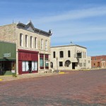
I am partial to Stone Buildings and Cottonwood Springs features many of them. They also maintain my favorite paving surface: Brick. I really like brick streets and was upset when Wichita tore most of them out some few years ago. They claimed brick is expensive to maintain but I don’t buy that. I think it is quite the opposite. Asphalt and concrete are in constant need of repair and that suits city officials and paving contractors just fine. I happen to know that the Germans have developed really nice semi-automated brick paving machines. I have seen these brick paving systems used down in Texas. A Brick Surface lasts a long time and is very smooth if properly underlayed. Most of all, most obvious in a place like Cottonwood Springs – Brick Has Character.

The Northwest Side of Broadway
A couple of doors South of The Emma Chase Café is the Flint Hills Art Gallery. As one would expect, the art featured is primarily the type of scenes I had just flown over. There is some nice work on display.


Looking Straight South Down Broadway at the Famous Courthouse
The Chase County Courthouse is indeed impressive. It is obviously well taken care of. It dates from 1873. Man, 1873! You don’t get any more “Old West Cowboy” than that. The day I was there a crew was finishing some exterior detailing. You can see one of their lifts in front of the building.


On the grounds of the Courthouse is this display shown below honoring local men who gave their lives in the two big foreign wars: World War I and World War II. It is amazing how many souls are listed.
Long before moving here, Kansas had a special allure for me. I have always thought of it as the “True Heartland of America”. As I grew older I wondered if this feeling was related to my exposure as a child to the early TV advertising of the Eisenhower Presidential Campaign and to the magic of the movie “The Wizard of Oz“. When I moved to Kansas from California in 1981, I tried my hand at selling insurance for a while. The company I worked for was a “no salary – commission only” outfit. We sold “A&H Insurance” (Accident & Health) to farmers around the state. It was extremely interesting to me to meet these farmers living in rural Kansas. After leaving the insurance game the one thing I remember about my discussions with the farmers was how they all talked about “going over there”. It seemed like almost all of them had joined up and fought in WWII and then come back to the farm. Many would show me their mementos from The War. I have always been impressed by that. They all did it out of Duty, Honor and Country. I didn’t hear one of them say he was drafted. That direct contact with the people of Kansas, in their homes while selling insurance, and daily over the last 30+ years has convinced me my childhood intuition was based on observable fact. This is The Heartland of America because it is inhabited by People of Great Heart.
The bronze bas relief inlay and solid stone monument shown below will hopefully last a few hundred years more and remind people in the future what real men were like in the 20th Century.


Looking North Down Broadway from the Courthouse

One of the Many Delightful Facades Facing Broadway
I decided I needed to walk over to the old bridge over the Cottonwood River. On the way there I saw a big sign stating only “Cowboy Trail Historical Courthouse”. Below you see said house. I figured I would be able to report more to you about it by searching the web but was mistaken. I could find nothing about it. Maybe somebody can fill in the blank on this interesting ediface…

Cottonwood Falls
As I said earlier, the Cottonwood River provides the border for the North end of town. It is a 2 minute walk down Broadway to get there. The water mill used to be situated on the South end of the spillway. Now there is only some foundation masonry remaining and some rusting gears that may be from the mill. Kevin said there was a movement to rebuild a replica of the water mill. That would be excellent, particularly if effort was made to restore it to working order using materials and building techniques of the time.

I suppose this area could be named for either the trees that line the river or the trees at the bottom of the spillway… There are lots in either case.

Here you can see parts of the old mill foundation and the water carry thru. If you look carefully at the top right corner of the carry thru wall you can see some metal gears.

This authentic mill stone is just South of the old mill site.
Also on Broadway is this fine restaurant and hotel known as The Grand Central Hotel and Grill. Kevin said it was an excellent place and the AAA gives it a “4 Diamond” rating. Debra and I will be visiting it soon.


Across from the Grand Central is this attractive stone building.
On my way walking back to the airport I saw this picture of stability – The First Presbyterian Church building. The sign on it says “125 Years”. Not knowing when that was put up I can’t say how old it is but, if you subtract that many years from 2012 you are in the 1880’s.

Below is what was until recently the school house for grades 1 through 8. It is a great looking building so I hope it is put to good use soon.

On the final stretch to the airport I looked up and saw a huge ring around the sun. I figured “if you don’t try, you’ll never know” and pointed the camera directly into the sun to get the shot you see below. The lens was “full wide” and still could not contain then entire ring. The ring represented the final remnant of the high humidity that had enveloped the region earlier in the morning. It was finally boiling off.

Ring Around The Sun

Man! Even the MXL and hangars at Cottonwood Falls took on a Classic Look.
The picture below was taken to show how close the airport is to the town. If you are a pilot you must visit Cottonwood Springs. It needs to be on your “Short List” for $100 Hamburgers.
If you want to do it right – make it a $100 Buffalo Burger!

Time To Leave
My lovely wife Debra reminded me the night before that we were going to her parent’s house for dinner. It was about 2 pm. I figured if I left then I would have plenty of time for “minor side excursions” that might strike my fancy on the trip back. (As you will see, that was a good choice)

After Liftoff Looking North Across The Center of Cottonwood Falls

Cottonwood Falls from 600′ and Climbing Looking Northwest with Highway 177 Forming the Right Border of the Shot

Downtown Cottonwood Springs From 1100′ AGL Looking Northwest

Strong City About 6 Miles North From 1300′ AGL

The Old Cottonwood River Bridge Seen From On High
I was so busy scanning the skies for traffic and snapping shots below that by the time I had encircled the town and got the pictures I wanted I was at 1800′ AGL. It was a good altitude to “catch the wave” home but I usually fly lower so as to get a closer view of the scenery below me. Regardless, in this case I decided to “stay high” for a while. The tailwind was giving me a 15 mph kicker. And since I was higher than normal, I deemed it a perfect opportunity to test the telephoto of my new Canon SX160is. The next 13 shots were all taken with “The Long Lens” and quick shutter speed. I believe the test was a success!

A Charming Ranch Set WAY OFF By Itself
I never expected to see an auto junkyard this far out in the country but here it is.


A Myriad of Cattle Tracks Coursing To a Dry Draw

El Dorado Lake 10 Miles to the Southeast from 1800′ AGL

I call this “Oyster on the Half Shell”.

From this altitude cattle look like gnats on a Rhino hide.


Potwin, Kansas with a Tall Antenna in the Fore

Potwin Again Looking Northwest from about 2000′ AGL
During the week of this flight, there had been much talk in local media about “green algae” infestation of ponds and lakes. I think this pond caught the bug.

Green Algae
Somebody got tired of running out of water and dammed up this creek not too long ago because it is still full of trees.

I noticed the car driving along the circular driveway leading to the house in the center of the picture. I can’t figure why they didn’t run the driveway a little more directly to the house…

Benton, Kansas & Stearman Field
By now I was getting closer to Benton, Kansas. For the previous two hours I was mulling over whether to stop at Benton or to bypass it and head a couple miles West to The Gliderport. The obvious answer finally hit me – Land At Both – and that’s what I did.

Benton, Kansas From 2000′ Looking Southwest

Crossing over Stearman Field to enter downwind for 35
Right off the North end of Stearman Field is the home of Victor Riffel. It is the one on the left shown below. Victor has a Stearman Biplane and a Cessna L-19. I have been interviewing him about his Stearman for Part 3 of my “That They Might Fly Again” series.

Stearman Field has two parallel runways – one asphalt/concrete and the other grass. I mostly land on the grass one. After landing on it I was surprised to see no apparent way to cross over to the restaurant. Victor had told me the owners of the field had been widening the hard surface runway and it looked like they were still working on it. I have but 6 inches of clearance under my main gear axle and I didn’t see anything that looked like a good place for me to cross. It wasn’t that important anyway so I waved to the folks at the restaurant, checked the pattern and took off for The Gliderport (aka: Wichita Airpark). During all that, it did not occur to me to document the instance with a photo so you will have to let your mind fill in the blank.
The Vintage Sailplane Association
As I approached the Gliderport I could tell something big was going on. The tow plane was pulling a glider to altitude. There were at least 3 sailplanes circling together in a mild thermal a mile from the Northwest tip of the runway. Also, the ground around the hangars was packed full of sailplane trailers. I took the shot below and then put my head on “ball bearings” scanning in all directions for traffic as I entered the pattern. In the 1980’s, when I first started flying Ultralights, I owned a Quicksilver MX that I hangared at The Gliderport. This place has been a mecca for Aviation Enthusiasts for decades.

The Gliderport
I landed and taxied to a spot closer to the North Hangar which also houses Belite Aviation.

The local soaring club is called Wichita Skylarks Soaring Association (WSSA) which is, if I get it right, part of the Kansas Soaring Association (KSA). You can read about it HERE. The Event du Jour was “The 7th Great Plains Vintage / Classic Sailplane Regatta” and guys had come from around the country to be there.
Due to their purpose, sailplanes are generally masterpieces of the aerodynamicist’s art. The well-known dictum can be suitably reversed: “If It Flies Good – It Looks Good”. They have all the elegance and fine lines of Jet Fighters without the noisy, smokey parts. Following are a series of pictures I took at the event.

The Local Soaring Club Trainer
I flew in the two seater pictured above back in the 1980’s with instructor Faye Edwards. The flow of the air past the cockpit is a delightful change from the relentless and intensely loud whine of engine and thrum of prop I experience in my Ultralight.

Just a Few of the Many Trailers at the Event

An R-1 CHEROKEE II Built in 1965

A NIEDRAUER NG-1 from 1971

This one’s wings had just been attached.


That’s what you call High Aspect Ratio!


This BJ-1B DUSTER came in from California
At times, I saw upwards of four sailplanes working the weak thermal Northwest of the field.


Aircraft assembly and dis-assembly is a constant in the Sailplane Sport. If you are standing around gawking you will be put to work in no time!

A SCHLEICHER KA 6 BR Based in Wichita Comes Together


Faye Edwards and I also went aloft in this trainer – the Club’s 1967 SCHWEIZER SGS 2-33.


One On Final – Many On Deck
I was told that the next Sailplane shown is particularly notable. It is a START & FLUG H101 “SALTO” and was designed specifically for aerobatics. This photo series featuring its assembly will show you a lot of the fine points of this interesting “V-Tailed” design.


A 1964 SCHLEICHER K8B based in Florida is readied on the field.
The SCHLEICHER KA 2B shown next is based in Wichita, Kansas. In addition to appreciating its elegant lines I vote it as the most attractive paint scheme of the show.


A 1958 SCHLEICHER KA 2B

Lots of Action at The Gliderport That Day

A 1964 SCHLEICHER K8B from Florida

A SCHLEICHER KA 6 BR Based in Wichita, Kansas

Rigging Done & Canopy In Place – Ready To Grab Some Air!

The Towplane settles onto the field, its towline attached and ready to pull another sleek craft skyward.
In the South Hangar, I was happy to see the once-familiar “Lite-99 Ultra-LIGHT” Quicksilver GT-400 fully assembled. It has been in pieces scattered about the North hangar for over a decade. My buddy Steve Ewing has reassembled it for the widow of the owner so she can sell it.

Also tucked away in the South Hangar was Doug Bryant’s Mosquito. Doug was the big star of The 6th Annual Ultralight Fly-In that occurred the previous weekend. For more about this Ultralight Helicopter and The Fly-In see the report HERE.

Still heading home…
When departing Cottonwood Springs I told you I was allowing time for a few stops and side trips on my way back to Selby Aerodrome. Since I would be heading over there for dinner later, I called my in-laws to tell them I would be buzzing the house. Here is a picture I took while circling above.

From 125′ AGL Looking Southeast
Big Airshow In Progress
Now you might think that with all I have shown you so far there couldn’t possibly be any more Aviation Activity in the area. You would be wrong. Hey, this is The Air Capitol of The World for no small reason. The weekend also featured McConnell Air Force Base’s “Wings Over McConnell Open House and Air Show” featuring America’s Ambassadors in Blue – The Thunderbirds. The FAA had issued a TFR (Temporary Flight Restriction) with a radius around the base of 5 miles out and from the surface to “real high”. I figured 10 miles out to be more wise. My home field, Selby Aerodrome, is just off the South Southwestern edge of McConnell’s Control Zone. So, after leaving The Gliderport I took a rather circuitous path toward that general direction. My plan was to approach Selby either before or after the “Big Jet” aerial routines. My tarry at The Gliderport put me in the T-Bird Show timeframe. I took the shot below from just West of Augusta Airport which is 11 miles from McC. It was depressing that the sky condition was totally unsuitable for photographing The Thunderbirds. I could have had some fabulous pix from this vantage point. The haze and general overcast did not allow for a proper contrast of the Smoke Trail they were making during some 4 and 6 ship maneuvers. I put these two shots in anyway so you could get a better idea what I mean.

The Birds are at the bottom of a dive obscured from this angle by their smoke.

If you look carefully at the right side of the smoke trail you can see the 6 ship formation climbing after pulling out of a dive.
The next day (Sunday), I went to the McConnell show after Church and enjoyed it very much. The weather was great, the air performances spectacular as always. I spent some quality time discussing various things with a B-1 WSO and a Bradley Fighting Vehicle Commander. I love those guys.
Still Heading Home…
Since The Thunderbird Show was in progress, I decided to divert to another airfield Southeast of Wichita called Cook Field. I stop in there frequently. Of late it is being promoted as a residence airfield and as such is starting to “take off”.

On the way to Cook Field I passed near Wink Hartman’s Ranch…

…which is not far West of the fair burg Rose Hill, Kansas.
Approaching Cook Field, it is always wise to be scanning for Sky Divers because there is a club headquartered there. I was a little surprised (but not shocked) that there were indeed some guys jumping during the McConnell Airshow. I “put my head on roller bearings” again scanning in all directions for traffic and saw two divers and their Jump Plane above the pattern. I kept an eye on all three and settled onto the grass runway after watching the Jump Plane land on the asphalt one.

The 3 dark specks you see in this picture are two sky divers with canopies open and a rapidly descending Cessna Jump Plane.

Cook Field from 1,000′ AGL Looking Southwest

Cook Field as I entered the Downwind Leg of the Pattern. Just below the hangars nearest the top of the photo you can see one of the sky divers touching down.

I was now on the ground. I was wanting to get the touchdown of this flyer but unfortunately his movement put the treeline behind his body in the shot. You get what you get sometimes…

Airshow Over – The Journey Continues
I hung out for a few more minutes at Cook so I could time it to beat it on over to Selby Field during the hiatus between aerial shows at the base.
Almost in the Cook Field pattern is the Diehl Brothers airstrip. These guys used to fly at the Gliderport and around the area a lot in the 1980’s but are not to be seen any more. You can see their airplanes in the hangar below. Actually I’m not sure the Diehls are even there any more. One thing I have noticed is that whoever is there makes it a point “not to wave” so I take that as a sign “not to land”. It is a private field.

About 2 miles later I saw the results of a fairly recent catastrophic house fire. Very sad.


This is what I call “bagging a train”. The full requirement is to zoom down into a field next to the engineer and see him wave at me. If that all happens I get to write it in my logbook as a “peacetime kill”. I saw this one just as I crossed K-42 Highway. It was a long one as you can tell by the 5 engine lead.


A Teepee in the Back Yard Just East of the Ninnescah River.
An Eagle Sighting!
As if I haven’t seen enough Aviation Wonders for the day, God tops my day with a sighting of one of his most majestic birds – An American Bald Eagle. Frankly I was hoping to see one. Over the last two years I have seen a couple in this very section of the riverbank. The air was particularly turbulent, roiling over the trees next to the river so it was extremely hard to get pictures of him. Just after the shot below, he took off but, “try as I may” I could not get a good tele shot of him in the air. Finally I lost sight of him. I think he dropped down under cover somewhere.


Autumn In Evidence All Around
Around here it is Summer right up until one pivotal day and then is is suddenly Autumn. It is like flicking a switch. Adjacent to the Southeast corner of Selby Airfield was this beautiful display of Autumn Color. I took the picture below on the Downwind Leg of the pattern.

Now on Final for landing, you see one of two tractors that were tilling the field at the South end of our grass runway.

You Never Know…
Like Forrest quoted his Mom in the movie, “Life is like a box of chocolates. You never know what you’re gonna get”. Such is Truth for The Sky Surfer and his trusty Quicksilver when out exploring The Wonderful Skies of Kansas.
Days like this are like jewels in a crown.
Blue Skies & Tailwinds!™
Brian FitzGerald
I enjoy all your flights.. Thanks Brian… Gnats on a rhinos’ hide… very descriptive
Dave O’Malley
Manager, Marketing and Communications
Vintage Wings of Canada
Gatineau, Québec, Canada
Thanks! I only hope the quality of my photos can approach the classic elegance of Vintage Wings of Canada.
I really like the stuff you guys put out.
This is good stuff… great photos… you wouldn’t think KS would look that good…but it does from the air… great Chronicle… the history aspect is cool also…
Talk soon…
Thanks, Bruce.
I appreciate the Hi 5. You are my California Contact. Helpin’ me keep it real.
I’m glad you like the posts. I put a lot of effort in them, and YES, Kansas is very beautiful. During Winter it looks a little bleak at times, though.
I’m getting the desire to record some more tunes and will probably do so this Winter. I’ll keep you posted.
Enjoyed your trip to Cottonwood Falls. I’ve flown in there twice and they have a lot of sights to
see. I hope you got to go through the court house. That was quite a building in it’s day. About
the Emma Chase cafe I think the food was great but the home-made pies were out of this world.
I’m still trying to locate Selby Airdrome on the map. Weather permitting I might fly to Eureka, KS,
Saturday the 20th, to a pancake breakfast. They start serving at eight am.
Keep the stories coming….
Good to hear from you, Joe. I’m glad you liked the story. I will return to Cottonwood Falls next season for sure.
I just checked Selby Aerodrome on Google Earth and have some data that will be of great use to a Cartographer such as yourself.
Latitude: 37°32’0.78″N
Longitude: 97°18’42.10″W
I just might join you at the Eureka Fly-In. It is on my list of places to go and I already have charted it in my system.
I may have an interview to record up in the Manhattan, KS area that day, though.
So, between that and the weather I am not sure if I will be able to make it.
Please remind me as we get closer.
Wow Brian, this was one of those really awsome flying days! Cottonwood Falls seems like a really neat town with some really neat people living there. It would be fun to spend a night in the Grand Hotel and have a nice long country breakfest at the local cafe. Looks like a lot to explore up there. The pictures at the Glider Port were great as well. Maybe that will be my next rating! I especially enjoy the way your so observant while your flying. Nothing very cool gets by that camera of yours. You make it very interesting and fun reading.
Doug
Thank you, Captain Moler. That is a great tribute from a professional aviator and member of a family of photographers. I think the trick to this is being ready to catch all that God throws at me. He put it all out there. I just need to be prepared and alert to catch it when it occurs. From the flight, the Bald Eagle sticks out in my mind. I actually had an “indication” to look for him and sure enough he was there.
Your upcoming “Falling Leaf Fly-In” next Saturday should be another milestone event for the region. I will be there.
Brian, thanks for the email. Very, very good. Come back to Cottonwood Falls any day. You diffently have a good way with words in your work and photos. Glad that you had a great time here. I’m sometimes hard to catch as I am out in the hills alot hunting, fishing, etc., but give me a call if your this way again. Oh yeah, Sammy Jo said if she knew she was going to get her picture taken she would have worn somethin more photogenic. Take care! Thanks again! Kevin
Thanks again for the tour of Cottonwood Falls and Strong City. It was a great introduction to an interesting area. I am telling anyone who will listen to fly, drive or walk up to your town and take a look. It is a special place. I’ll give you a “heads-up” when I head back up there next season. Let me know if you fly down this way.
WOW pal….the best 2 1/2 hours I’ve ever spent looking at pictures and reading the descriptions….loved it all….congrats to you on being able to spend part of your life this way….I envy you pal…Thanks for sharing….S
Dear Stan,
Nice to hear from you and thanks for the encouragement. I hope all of the posts on The Flight Blog can be that good but “you never know what you’re gonna get”. I’m heading to a Fly-In at Wellington, Kansas in a few minutes. It will not be an epic journey but I’ll take a few pix and post it later in the week.
See you soon!
Brian
Thanks Brian for sharing your photos. We particularly appreciate the photos you took at the Vintage Sailplane event. I also found the flint hill photos beautiful. Being a glider pilot, I’m not used to be so close to the land without being very busy in a landing pattern.
Thanks again,
….. Neal
I am very pleased that you enjoyed the story. I spend a lot of time on these travelogs and really want to both: (1) expose more (civilian) people to the joy of sport aviation and (2) reinforce that concept among flyers themselves.
I was impressed how many guys showed up from around the nation to be in Wichita for the Regatta. I wish I had had more time to cover it.
Brian; Thanks for sending all trip writings & pictures! Especially this last one on Cottowood Falls—- it took me back to William Least Heat Moon’s “Prairy Erth”. Again; great job on the last ” show & tell!
Steve Beasley Yoder, Ks.
It is very gratifying to hear your comments about my travelogs. I truly appreciate the comparison to Least Heat. You have peaked my interest about his book which I have not read. I’ll keep in touch.
I stumbled on to your Blog while looking for new Luscombe photos and seeing your picture of Kevin and his beautiful Luscombe. Since then I have spent hours reading your stories andlooking at your GREAT photos. Thank you for sharing your view of this great country.
How excellent is that! I am glad you have found Sky Surfing. I have taken the liberty of adding your name to the mailing list so you will know when something new is out (my mailing list is NOT used for any other purpose). I have a few other contributors that also provide great pix and write-ups. If you decide you want to post anything, let me know and I will upgrade your status to “Author”.
Brian,
I am not an aviator nor am I photog or videographer. However, I did grow up in Cottonwood Falls and found your blog strictly by accident. Let me just say, “Thank You.” Your journey to my hometown was told beautifully. The Flint Hills, Cottonwood Falls & Strong City are gems of Kansas and I think your story and photos truly captured their beauty. I now live in Kansas City but each and every visit home (my parents still reside in those parts) I am appreciate the landscape more and more. I hope your writings have spurnned many fellow aviators to journey up to Cottonwood Falls.
Thank you again for your words and pictures. Stay safe in your journeys!
David
Dear David,
I am so glad you found the Cottonwood Falls story and can testify to the veracity of my observations. As with so many of the wonderful places I fly to on my “Sky Safaris”, I struggle to choose words and shoot pictures that accurately describe the majesty and quiet elegance of The Prairie and the Special Small Towns I am able to visit.
I have many trips lined up this coming season. I hope all of the stories will convey the Great Plains as the magical places you and I know them to be.
Blue Skies & Tailwinds!™
Brian FitzGerald – Wichita