Because It’s There
I mentioned to someone I was flying to Pratt, Kansas. They asked why I was going there and the first thing I could think to say was “Because It’s There” – which is true. There needs be no better reason for a Fun Flight than to go somewhere “Because It’s There”. Being airborne is the prime directive anyway. The destination is icing on the cake. But, in the case of my recent flight to Pratt, Kansas, I was going not only “Because It Was There”, I was going particularly to visit The B-29 All Veterans Memorial – and to land at the famous Pratt Army Airfield, a genuine B-29 training base from World War II.
Something Different For Readers of “Sky Surfing”
I often begin these Fun Flight travelogues by showing my Quicksilver outside the hangar, at the ready, itching to fly. I try to shoot it from different perspectives so as not to be repetitive. Even though it’s the same plane I want to give y’all some variety. This morning a unique vision of the sunrise caught my eye as I pre-flighted the airplane. I captured it and will start this story with that daybreak image.

Kansas Sunrise Photo
Time To Get Smart
In previous entries to this blog this summer I have noted that the combination of wind chill, humidity and ambient air temperature can combine result in “freezing of the phalanges” (a la Limbaugh… For those of you in Rio Linda, “frozen phalanges” means cold fingers). This can happen even when the temperature rises over 100 degrees later in the day. So, after bearing this discomfort about three times in a row, my lightning fast mind finally decided to better dress for the occasion. This flight I actually wore gloves. I am glad I did because even with gloves, my windbreaker and long pants, I was still shivering all the way to Pratt. Only while flying the leg home did I warm up a little, staying low just to pick up some heat off the sun-warmed fields…
After takeoff I climbed to about 800 feet and headed West Northwest. To the North of my path I saw the familiar sights of Air Products and the DeBruce Grain Elevators.

Air Products & DeBruce Grain Inc.
My flight path to Pratt would take me just outside the Southern edge of the Wichita’s Mid Continent Airport control zone. Even though I follow the big arrow on my marginally trusty GPS, I always check my “ground markers” to make sure I am clear of this zone. The main marker in this regard is Rucker Field which is adjacent to a Cell Phone Tower right on the edge of the Control Zone Circle. I always pass over Rucker to make sure I am clear of this controlled airspace. The bonus is being able to wave at anyone who is in or around the hangars at the field.
Today as I headed West I was greeted by the vision of a large FedEx plane passing over my path to land at Mid Continent. I think it was an Airbus 320.The picture below doesn’t show the plane all that well but you can get the idea of the scene. I think it is neat from a position in the air to watch a large craft like that descend to land. It is far different from seeing the same plane land when watching from the ground. Because they are so large, aircraft of that size seem to be traveling very slow – just crawling through the air. I am also amazed at how quickly they descend once they get on final. It made a good morning better and helped keep my mind off the chill I would be enduring for the next 2+ hours.

FedEx Plane On Final
Day Early – Shadows Long
One of the interesting visuals I enjoy when making my Sunrise Flights are the interesting shapes the long shadows make across the ground. I took a few pix to give you an idea.


This one isn’t about the long shadows but about the interesting shadow the sun makes of my airplane on the plowed field.


Dense Population
Compared to my flights heading East, South and directly West of Selby Field, the path leading to Pratt, Kansas covers some pretty densely populated areas. Of course I say that with “tongue in cheek”. Anybody from the big cities or seaboard areas of the country might consider this area “completely uninhabited” from their perspective. For me, though, when I make my low level, cross country adventures, if I see a farmstead every mile or so it is getting pretty crowded. I love seeing the farms and admiring their fields, buildings and equipment but if there are a lot of them I have to be more attentive.
It is illegal to fly too low over people’s houses without permission but mostly it is “bad form”. 99% of the people in the country wave at me as I fly by their farms or over their fields while they are driving their tractors or other equipment. In other words, they like to see my bright yellow bird drift across the landscape. But, even if it wasn’t illegal it would be “uncool” to buzz people’s houses. I stay a respectful distance from them and wave if I see folks out and about. More important than staying clear of houses, though, is to stay away from the livestock. The worst of “bad form” is to spook cattle, sheep, swine or particularly horses in corrals. Milk cows are particularly sensitive to aggravation. When I see the signs of a Dairy Farm, I make special effort to give it wide berth.
Range Cattle
For the most part, range cattle are not upset by my passing. Through many hours of study, I have turned flying near them into an art form. It is my observation that you can get within 100 yards horizontally of cattle and they will not move an inch as long as you do not appear to be coming directly at them. If you make a gentle curve around them the herd will just gaze at you while eating their grass. At most, the adolescent calves will get up and walk toward their Mothers. When flying higher, I can pass directly over range cattle at 600′ and 95% of them will not even look up. When flying low in the country, you just have to pay attention ahead, look for livestock and then plan a path that satisfies the requirements for being a “Good Citizen Sky Surfer“.
Oil & Gas Is Good
Notwithstanding the bleating of the “old school” media and the current Administration, Real Kansans Love The Oil & Gas Business. I think I can say that Real Americans Love The Oil & Gas Business. Heck, I wouldn’t be in the air if I had to depend on electricity generated by a Wind Turbine. Would I have been able to get to my airfield on some type of electric train??? an electric bus??? No! Oil and Gas are produced in significant quantities in Kansas and I am 200% in favor of the searching, drilling and production of it. I say these things because next you will see some prime Oil & Gas property East of Kingman, Kansas. The installation below is isolated by itself out in the country. I believe it is owned by Oneok. Although I am not in the business, I have picked up a few things by observing it over the years. I have been fortunate to have done some movie making work for a client that has allowed me entrance to a fairly large refinery. That level of exposure and the observations I have made while around that business makes me think this installation is some type of Gas Unit. Probably there is some separation of the gas done here and pressurization of it for moving out by pipeline. Regardless of what this installation does, it indicates there is a lot of gas in the ground here.


Low & Slow Flight
As you can see from the previous pictures, I am flying fairly low. This was part of The Big Plan this morning. Besides the previously mentioned reasons, another one for settling on Pratt as my destination for this flight was that the weather forecast was for Northeast Winds that day. Regular readers of Sky Surfing will know that by commencing a flight at or before sunrise, I have found that I can fly 90+ miles into head winds of 20+ mph while sustaining only 6-8 mph of ground speed loss as long as I fly “nap of the earth”. That is “mil speak” for flying really low. On this particular day, even though the head wind was about 15 mph, 90% of the time I observed NO loss of forward speed on my GPS. YES!
Shortly after passing the Oneok Gas Plant I came upon the village of Murdock, Kansas. Below is the view of Murdock from about 100′ looking Southwest. As you can see the shadows are still quite long. It is only about 7 am.

Murdock, Kansas
Next, just East of Kingman, Kansas, we see these interesting “washes”. I know they aren’t much use to farmers or cattlemen but they are very attractive to the eye. For me they really evoke the Old West.


Ghost Train
Just outside of Kingman, Kansas I came upon this interesting discovery. I thought I had more pictures of it but I just have this one. Below you see what looks like a long train. It is, but it isn’t. All of these cars appear to be brand new but there is nothing in them. They were not hooked to a locomotive either. They are just sitting there. They are made of aluminum and are very shiny. Between the Western end of this long row of cars and Kingman, the track has the appearance of disuse. From all this observations, my best guess is that this is a holding area for a grain car manufacturer or retailer. Maybe someone can confirm or correct this guess.

The Ghost Train Flanked By The Sky Surfer Shadow
Next is a series of photos featuring Kingman, Kansas from about 800′ AGL. Kingman is an excellent example of Kansas Small Town Living. A while back I made a flight to their delightful airport and wrote it up here. I stop there on occasion but today did not want to spare the fuel needed to land and climb out again. As I entered the area, I could see a light plane in the pattern of Clyde Cessna Airfield which is on the North side of Kingman. I’m betting it was Robert Crow – CFI, who teaches the Fine Art of Flying from that airfield. He stays busy in Kingman. Every time I have been to the field he is teaching.
This series of photos of Kingman was shot from about 1,000′ AGL – looking Northwest and then Northerly.


The Kingman County Fair Buildings

Downtown Kingman, Kansas
Upon exiting the general Kingman airspace I dropped down to Ultralight Flight Level 75 to continue my trek to Pratt. I saw these guys cutting some dried out corn. The only reason I took the shot is that I was surprised to see this so late in the season. Every where else I have flown in the previous two weeks, the dead corn had already been cut down.

It was a little South of my path to Pratt but I decided to swing over and get these next two shots of Cunningham, Kansas so you could see it from the air. When I first moved to Kansas from California I sold Accident and Health Insurance for a couple of different firms. We would travel the small towns of Kansas going from door to door. One of the guys I remember from that time was named Randy. I can’t think of his last name. He was always cheerful – A Hale Fellow, Well Met. He was a helicopter pilot but not able to find work in that arena for a while and took up insurance sales to cover the gap. Every time I pass by Cunningham or hear about it I think of Randy.

Cunningham, Kansas From 200′ AGL Looking Southwest

The Main Street
Below, more signs of wealth discovered below the ground – the MXL cruciform shadow beside.

Pratt, Kansas and Pratt Regional Airport
Right on schedule I began to see signs of Pratt, Kansas. I have been there quite a few times – even as recent as a month prior to this flight. All of the other visits to Pratt were made chained by gravity to the ground, though. Today I was floating above the mere mortals below and everything had a new, fresh look.
I like to arrive at my destination with about 20 minutes of fuel remaining in the tank. The design of the Quicksilver MXL makes gaging your fuel load a snap because the translucent gas tank hangs about a foot over your head. You know exactly how much gas you have left in the tank. As I shot the picture below I figured I was right at the 15-20 minute reserve point. Rather than shoot my aerials of Pratt at that time I decided to get them on the way back to Wichita after landing and looking around Pratt Regional for a while.

Pratt, Kansas – As Seen From Approximately 3 miles Northeast At 150′ AGL
Just after the shot above I came upon this business seen below just off Highway 61. I thought it looked neat so I took a picture of it. My examination of it leads me to believe it has something to do with food processing.

Just after shooting the food processing plant picture I looked Northwest of my position and could see Pratt Regional Airport exactly where it was rumored to be. Just like used to be more common at aerodromes, a tall red and white checkered tower marked it as an airport very clearly from this distance.
Even though I saw no traffic in the area, as is my habit and training, I climbed to pattern altitude to make my entry into the Pratt Regional Airfield airspace. I think it is important to follow pattern discipline any time but particularly when entering an unfamiliar airport.

From the next two shots you can see the great expanse that was one of the training bases for the most expensive weapon system of WWII – The B-29 Super Fortress Bomber (I think the development of the Atom Bomb probably cost more but I don’t consider it a “weapon system”) When built, it was called Pratt Army Airfield. It was the first B-29 installation built and home of the 58th Bombardment Wing. At that time, it had three interlinked runways joined in a triangle fashion. Today there is only one active runway – the North/South. The others are used for cattle feeding operations.

Pratt Regional Airfield From 1200′ AGL Looking Northwest

There was no traffic in the area so I crossed over the landing strip to get a better view of this huge cattle feeding business. I could not find the name of it but I think Randy Huit (whom you will meet in a moment) told me they feed 30,000 cattle at a time.

I only loitered above the cattle pens long enough to get the shot above and then I entered the pattern for a short downwind, crosswind and final. Putting an Ultralight down on a massive landing field like this is like using a football field to park a Mini Cooper. Overrun is not a concern…
The first thing I did was tie down the MXL as the Northwest wind was now building at the surface. The Pratt tiedowns are superb with decent rope and rings embedded in the concrete.

In the distance, just under my right wing, is the home of Pratt Air, Inc.

The Sign on the Side of the Pratt Air Hangar/Office
As I walked into their office I was warmly greeted by Curtis Huit the “Father” of the Father and Son ownership team of Pratt Air, Inc. The office features a counter with a computer for flight planning as well as the sale of maps and other items one might need for aviating. Curtis was spending a pleasant Saturday morning at the office reading the Pratt Tribune. I said hello and told him I had called his son up the day before. I asked if Randy was around so I could meet him. He took me over to Randy’s office in the hangar.

Curtis Huitt Starts The Day

A Flight Planning Workstation

A framed copy of Curtis’ Logbook with entries leading up to Solo.

One of the interesting artifacts of the Pratt Air Office/Lobby is an elaborately inlayed coffee table that was once in Walter Beech’s offices.


The Top of the Beech Table
They also had this picture on the wall of Fifi – the only flying B-29. Last Fall I traveled to New Century Air Center, outside Lenexa, Kansas to get video of this monster. I will be incorporating it in an upcoming segment of my “That They” series.


The Unicom and Weather Data (note my MXL outside at tiedown)

Randy Works the Phone while Curtis Examines the Paper
The DHC-1 Chipmunk
After Randy was freed up from some pressing matters he showed me around the place. On the bulletin board was a picture and description of a DHC-1 Chipmunk. I had seen one before at the Gardner, Kansas Municipal Airport. They were designed by deHavilland of Canada, are aerobatic and feature an inline engine.


The Chipmunk is in excellent condition. The paint looks new and is very shiny. It is not completely stock, though.

Randy Huitt and N9261
Randy opened the engine compartment to reveal a fuel injection kit on the motor.

A Labor of Love
We jumped into Randy’s pickup and headed over to see if anyone was stirring this early over at the museum. When we arrived it was empty and the door was locked. The “indoor” part of the B-29 Memorial is housed inside a renovated Parachute Barn. This is the original building that was used to ready parachutes for use during The War. The tall part you see in the picture below is where they would hang the ‘chutes to make sure they were dry and to check for rips before folding them.

The Parachute Building
In essence, the Parachute Packing Building not only houses a variety of artifacts, but is a restored artifact itself. The entire inside of this building has been renovated back to the original state it was in World War II by Volunteer and President of the B-29 All Veterans Memorial Museum – George Stevens.

President George Stevens Next To One of the Displays
The reason I was able to get the shot of George Stevens above was that providentially, as we were just getting ready to leave the Parachute Building, cars pulled up to the door. Volunteers were there in order to ready the facility for the arrival of a group of motorcyclists from Larned, Kansas coming to see the museum. The bikers were also participating in a fundraising “drive” for the Red Cross and would arrive soon. So, in addition to President George Stevens, Red Cross Volunteers John and Dona Cochran had arrived to set up a Red Cross table, too.

John and Dona Cochran hurry to ready their display for the soon arriving group.

John and Dona Cochran of Pratt, Kansas
I took a number of shots of the inside of The Parachute Barn so you could get an idea of the place. This newer “inside” addition to the B-29 All Veterans Memorial is a great start to what I’m sure will continue to build over the next few years. One of the great testimonies to me about this place is that it has been built and funded by citizens. They didn’t hunt for grant money from Washington or Topeka. The folks of Pratt decided they wanted to honor the sacrifices of our war heroes so they made it happen themselves. Starting from the basis of this WWII B-29 air base, they reached out to commemorate the efforts of all our Veterans. At the heart of this is a tribute that money can’t buy. I am very impressed with their effort.
UPDATE 17 Sept 12: After posting this flight journal I received an email from Milt Martin, the Archivist of the B-29 All Veterans Memorial. He wanted to give me some more information about the restoration process and to give credit to others who have been involved in the effort. Here are those details:
- The B-29 Memorial area was completed in 2003 funded by locals and donations at its open house/banquet. Robert K. Morgan (trained on B-29 at PAAF with 497th Bomb Group) was speaker.
- The only grant so far is for restoration of exterior of parachute building. It was from the Kansas State Historical Society. Called a “Heritage Grant” it was about $58,000 (the group matches with 20%). It is about 2/3 complete.
- The interior work is funded locally with events connected with memorial day and veterans day plus volunteer labor (mostly George Stevens work).
- The local Chamber of Commerce tourism committee plus local businesses have donated some operational funds and advertising funds.
- They also sell Memberships, 20 bucks per year or 200 dollars lifetime.
- A modern secure library/records center (for all B-29 Bomb Groups trained in Kansas) is planned depending of course on funding. We will seek Foundation Grants from firms involved with the B-29 program, aviation or newer technology businesses.
- He said they have received “great support” from citizens of the Pratt Community as well as the Pratt City and County Governments.
- Long term, they also would like to become a CAF squadron sponsored by Jayhawk Wing of Wichita.
This first shot below is important to me because I am the proud owner of five of the same rare paintings/posters seen in the photo. This display features the collection of an Air Force Officer from the Pratt area. I am remiss for neglecting to write his name down. This Pratt native served in Viet Nam at the same time as my Father – Col. G.F. FitzGerald. After my Dad died I received these Fighter Pilot Artifacts from his collection. The two seen below on the wall that I have are the ones showing the Fighter Pilots standing. One is serious and the other a “send up”. Laying on the table and positioned on the easel are dramatic paintings of the Republic F-105 Thunderchief that I also possess. My Dad and men like this Officer from Pratt, flew the Thunderchief deep into North Viet Nam under the most challenging of circumstances to destroy innumerable Communist targets against intense AAA fire and SAM missiles. If you want to learn more about these battles, read “Thud Ridge” by Jack Broughton.

The next few pictures show other displays of memorabilia inside the Memorial. Note the walls, window sills, floor, doors, etc. All of this has been returned to its original state when built in the 1940’s.


This picture is looking up into ceiling and racks of the parachute hang area.

An aerial photo of Pratt Army Airfield taken during the War.


As we were leaving the Parachute Barn, Randy showed me something interesting that had been recently donated but not yet put on display. These two tires and one wheel are from the nose gear of a B-29.


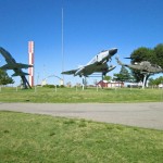
We then drove over to the outdoors portion of The Memorial. This is where the aircraft are mounted on display. It is adjacent Highway 281. These were the aircraft I saw late one evening while driving down this highway heading back to Wichita with my lovely wife Debra. That night we didn’t have time to stop and look around. But, even so, I figured these aircraft would be better visited as part of an Ultralight Adventure. That time was now.
The first shot below is from the East and best shows the three warplanes. I really like the way they mounted the aircraft in “action” poses. The two jets are blasting into The Blue Yonder and the Cobra is setting up for attack. This is the way warplanes should be seen – Valiantly. There is an F-105 on display at McConnell sitting absolutely “straight and level” and low to the ground. I have always thought that pathetic mount as dishonoring the air workhorse of The Viet Nam War. It should be re-mounted in the manner we see these Warriors in Pratt.

L to R: A Northrup F-5B/T-38, An F-4 Phantom II, An AH-1 Cobra Gunship

This is the same area of the memorial but as seen from the West.


After showing me around the field, Randy needed to get some work done and I needed to head back to Selby Aerodrome.
If you are looking for a reason to fly your airplane somewhere, I definitely recommend going to Pratt Army Airfield – AKA Pratt Regional Airport. Randy and Curtis Huitt (Pratt Air, Inc.) are great hosts and their fuel is reasonably priced. If you want to see the indoor portion of The Museum, be aware it is staffed by volunteers. You should check their website or call 620 672 1944 to see if the doors will be open upon your arrival. There is also a Courtesy Car available on the field if you want to go into town.
After bidding adieu to the Huitt’s, I made my walkaround (it’s always good to see if anything fell off your plane on the trip up that you might need on the trip back…) and fired up the motor. It was about Noon. As per my plan, the wind from the Northwest had increased a bit and would provide me a tailwind home.
Pratt, Kansas is only 2.5 miles South of Pratt Regional Airport. After taking off to the North I made my left hand pattern and egressed South. After scanning for traffic and seeing none I settled into some photography of Pratt seen next.

Pratt, Kansas from 1500′ AGL Looking South Southeast About 2 Miles Away

Closer

Downtown Pratt From 1500′ AGL Looking South Southeast

I saw the Pratt Water Tower and figured you needed to see it.
Even More To See At Pratt
Southeast of town is a very interesting place called The Pratt Fish Hatchery. It has been there since 1903. I have not had a chance to visit there yet but my wife and I took our children to a similar one in Colorado years ago. They are very interesting and worth the trip. Idea! You could fly to Pratt Army Field, check out The Museum there, borrow the Courtesy Car, go into town for lunch and then visit the Hatchery. Now that I planned your trip for you, there is no excuse not to fly over some time soon.


Adjacent to the Hatchery is The Pratt County Lake. I would hazard a guess that it might be a good place to fish.
After taking the pix of The Hatchery area I began my flight home. Since my game plan was to ride the wind home that day, the best way to do that is at about 1,000′ to 1,500′ AGL. You get as much benefit of the tailwind as you are going to get without wasting fuel climbing any higher. In addition, you are still low enough to see the sights. Unexpectedly, though, it was still a bit chilly. So, I tested altitudes and ended up back down around 200′ AGL for the trip home. I still got about a 4 mph kick from the tailwind. More importantly, though, I received the warmth of the intermittent thermals reaching up from below. It became more and more turbulent as the flight continued, though.

A Lonely, Unnamed Bridge Out On The Prairie
Things That Normally Pass Our Notice
The reason I took the picture of the bridge above is not particularly related to the bridge itself. The bridge is fairly new and in good repair. That is not the reason for taking this picture either. Rather, I would draw your attention to all the unnoticed bridges we have across Kansas and these Great United States. 100 years ago, bridges like these that are common to us were quite rare. When you get up in the air and fly out in the country and pay attention to the bridges, you will be amazed how many you see carrying traffic over small creeks, washes, gullies, creeks and rivers. Most of them are much smaller than the one seen in the picture above.
This leads me to two points
First: The next time you are driving somewhere, imagine how difficult it would be to get to your destination if the bridges you cross were suddenly not there. Maybe you would have to ford the stream at a low point (IF the stream was low…) or for larger bodies of water, you would have to wait for a ferry to cross. Maybe there would be no way to cross and you would have to go around the obstacle. These innumerable, nameless bridges save us countless hours and make Kansas (and America) a more enjoyable and efficient nation in which to live.
Second: You might think the benefit of these bridges is because our Government taxes us and builds the bridges. That may be so, but consider that most every inhabited place on the earth is under some type of government. “Government” when viewed under that context and as practiced in most of the world is highly inefficient and mostly corrupt.
I submit to you that the reason our American society is able to work together in ways mostly unheard of (outside pockets in Western Europe and Australia) is because of Christ. Regardless of President Obama’s vacuous statement claiming the opposite, it is plainly known and obvious that America has been and is a Christian Nation. Does that mean that every person in the country is a Born Again Believer? No. But, because a large enough contingent of American citizens follow Jesus, His presence is evident and gracious throughout The Land. Christian principles suffuse our lives, businesses and government here in ways that are unheard of in non-Christian nations. We have Money that can be Trusted. Honest Weights and Measures. Property Rights. Freedom of Travel. The Right to a Trial by One’s Peers. Etc, Etc… Get my drift? Jesus said He wants us to have Life and have it more Abundantly and THAT is why America is great (John 10:10). Woe be the day if the majority of Americans turn their back on Jesus. You may be skeptical of my view but if you want to know more about Jesus, I would be pleased to help or will be glad to introduce you to a Pastor that show you more. Sermon over..
The Flight Home Continues…

Passing Kingman, Kansas again from about a mile South Southwest at 150′ AGL

Murdock, Kansas from the Southwest at about 300′ AGL
Below is a shot of an active oilfield not too far East of Murdock. I was trying to get a better shot but by now the air was very turbulent.

Try This Some Time:
To approximate the task of shooting pictures in turbulent air, try taking pictures from the back of a horse going at a slow trot while it works its way randomly through some waist high brush. Stand up in the stirrups and use your body to “stabilize” the camera so that the horizon is level. That is the best parallel I can generate as to what I have to do to take pictures from my Ultralight when the air is turbulent. Also, because most of the time I don’t want to see parts of my plane in the shots, I lean out to the side of the cockpit (yes, my seatbelt is still on…) and let the plane “go how it will” until I get the shot.
This brings up another great characteristic regarding flying that non-pilots don’t understand.
Flying Is Far Safer Than Driving A Car or Motorcycle On A 2 or 4 Lane Road
The Art of Aviation has an unwarranted reputation among the general public for being the province of daredevils and for being “just plain dangerous”. Mention you are flying an Ultralight and any previous suggestion of your sanity is cast aside. This Is Ignorance (notice I didn’t make any disparaging comment).
Here is my explanation. Like the bridge discussion earlier, this will involve revealing things people encounter every day but fail to realize the full import thereof.
One of the 2 lane highways I fly over a lot (and have also driven my car on) is Highway 81. Through Wichita this is known as Broadway Street. As it passes out of town on the South side, it passes through open country. Every time I fly over it I am mesmerized by the scene unfolding below me. Large 18 Wheeler Trucks are constantly coursing North and South on this stretch. They pass each other going opposite directions with roughly 8′ or less of space separating them. If you assume they are driving 60 miles per hour, their “closing speed” is 120 miles per hour. What that means is if they were to collide “head on”, the crash would be equivalent to hitting a wall at 120 mph. Driving vehicles on a small ribbon of asphalt requires enormous attention to the task at hand. As we all know, just a nanosecond of fooling with the radio, “texting” a friend or just plain daydreaming can put a car, truck or van off the road or into oncoming traffic in the blink of an eye. Most of the time, when an event like that occurs, people involved don’t even remember what happened because it happens so fast.
When something is commonplace and necessary to everyday life, people become inured to potential danger. They ignore it to the point of not seeing it.
Now, I drive a lot and so does everyone I know. I think driving on Kansas Roads is an acceptable risk/reward task. I just submit to you that physics make driving across town more dangerous than flying an Ultralight to Pratt and back.
Here Are Some of the Reasons Why Ultralight Flying (and Flying in General) Is Inherently Safe
My Quicksilver, just like all properly designed aircraft, is Dynamically Stable. This means you can trim it for level flight and take your hands and feet off the controls and it will not “fall out of the sky”. In other words, almost all aircraft will in essence “fly themselves”. No doubt this concept needs much more discussion than I am making here. Suffice to say this… You CAN: fool with your GPS, mess with your radio, daydream for a while or even take pictures with your camera using both hands and the plane will not “veer off the highway and hit a tree”. Flying requires paying attention but it is not the same kind of “riveting attention” required to drive a car – except when landing. Now this is not to say a good pilot shouldn’t be scanning the sky for traffic or radio towers, etc. The point is that nearly all pilots will pass their entire flying career without intersecting head-on another aircraft with a separation of only 8′! The only guys I know of who do that trick on a regular basis are The Thunderbirds and The Blue Angels. They spend hours of quality time learning how not to kill each other while performing the stunt.
Because flying is performed in Three Dimensional Space, it does not afflict on its pilots the same consequences born by drivers occupying Two Dimensional Space should the “concentration to task” momentarily break. The exception to the rule occurs when performing two tasks peculiar to aviation. These two must be successfully accomplished during every flight of an airplane: Taking Off and Landing. Since these two skills are alien to human experience, they are often the deciding point as to whether a mere mortal can become an Airman or must be forever consigned to the ground. Even then, taking off in an airplane mostly amounts to training one’s feet to steer a machine rather than using ones hands on a wheel as seems more natural. This makes Landing the potentially dangerous part of flying.
Once the technique of landing an airplane is mastered, the only things that get you into trouble are Bad Maintenance and Bad Judgement. Volumes and volumes of books have been written on these subjects by men with WAY more hours in the air than I so I will stop haranguing you on this now. If you are not a pilot, though, I hope I have given you some reasons to believe that flying Ultralights or any Aircraft is inherently safe. Believe it or not, sport aviating is quite relaxing as a pastime.
Back To The Flight…

The South Fork of the Ninnescah River
I did my best on the next couple of shots to get a “time lapse” of these Snowy Egrets lounging on this pond. As I approached them I knew they would circle up and fly away. Unfortunately the air was too rough and the other shots I took were too “smeared” to use. You get the idea, though.


Because I had a tailwind my fuel disposition was good as I pulled into my “general neighborhood”. That neighborhood includes Lake Afton, shown below, which is only 18 miles from my home base, Selby Farm Airport. I decided to swing North and pass over it. Lake Afton is a County Park and when the weather is nice lots of people go there with their boats and campers. It also boasts an observatory, an RC Landing Strip and a 100 Yard Shooting Range. I like to fly over it and wave to the people below. This day I got a bonus for my effort…

Lake Afton Looking Northeast from 200′ AGL
As I approached, I saw really fast moving objects on the roads that run through the park area and around the RC Airplane Field. At first, because they were taking the turns so fast, I thought they must be Radio Controlled Race Cars. They were making the turns at abnormally high rates of speed. The closer I got I decided they could not be RC Cars because they were going too far along this track. It would be too dangerous to have something going that fast only to lose radio contact and crash into somebody. As I chewed on that thought, I became close enough that it finally hit me – GO KARTS! Actually when I checked on the web these are called SUPERKARTS. I’ll have to describe them because unfortunately I could not get a decent shot of them from the air. It was just too turbulent for me to snap the shot when the karts were visible and keep the plane reasonably straight and level. Anyway, here is a link so you can see what they look like. To me they look like scaled down Formula Racers. I figure they were going at least 90 mph. They are so low to the ground they don’t seem to slow around the turns at all.

Well, at least you can see the track they were on. The racer I was trying to photograph is behind the tree near the center of the shot. You can see some dust in the air.

Here is the “Pit Area” and the one Racer I accidentally captured in these shots. You can see him at the very bottom right of the frame.

I made a 180 and came back through this area hoping to luck out and get a racer in the shot but no joy.
I decided one pass at the area was enough and if I was able to capture some racers in my shots that would be great. At an event like this I think it “bad form” to draw too much attention to my sport while these people are enjoying their sport. It was time to head back. I had been in the air for two hours already on this return leg.
Even though I was on the final stretch I still had one more mandatory activity – that would be my obligatory pass down Rucker Field. Heading in that direction, though, I again saw this curious development I have been noting on my last few flights through the area. Below you see a new unoccupied house and beyond it a large lake being dug.

Adjacent to S. 135th St. West Looking East
As best I can figure, the owner of this property is paying a steam shovel operator to dig this big lake. If you look carefully at the picture below you can see the shovel at the far end of the dig. Because the photo “could” be perceived as reflecting off water, I am here to tell you that is all mud except for some small trace water puddles here and there. It probably isn’t the first or last time, but I can’t remember seeing someone dig a lake around here with no natural creek or river feeding it. They must intend to fill it from a well or are hoping for lots of rain.

I feel like I must continually apologize for these pictures but the turbulence was so strong I was forced to shoot the picture above and the one below “blind” and with my left hand. I’ll do better next time.

The Low Level Approach to Rucker Field
As I made my pass downwind at Rucker, I was having to wrestle the plane quite a bit. I attempted to shoot a picture over my right “stick arm” of the hangars you see above as I made the pass. It turned out bogus so I did not include it in this blog posting. But, after making the pass, I made a climbing left turn into the wind and snapped the shot below showing Rucker Field’s three hangar buildings.

The Rucker Field Hangars from 200′ AGL Looking West

One More Shot of Air Products and DeBruce Grain
I talk a lot about my home field being South of Haysville, Kansas so I thought I would show you a picture of the West Side of the town and its Water Tower.

As I came closer to Selby Aerodrome I saw a KC-135 on final heading in to McConnell AFB. You can see it just above the horizon in the shot below.
AND, just as I am writing this, I notice at the very bottom of the frame are two 18 Wheelers coursing down Highway 81 as per my earlier, long, drawn-out dissertation on The Safety of Flying. If only one of them had been approaching from the South when this picture was taken my dissertation would be complete.

A KC-135 On Final Approach to McConnell Air Force Base
After I made a few circuits of the field I settled the MXL onto the turf and taxied into the hangar. There I beheld hangar mates Don Forse and Bill Bailey immersed in the study of a sectional map. After they read this story, they will probably fly to Pratt, too… “Because It’s There”.

Don Forse – Titan Tornado Flyer & Bill Bailey – Taylorcraft Flyer
So went the close of yet another great day in the Kansas air – at least 5 hours worth anyhow. I’m looking forward to a new adventure next weekend as soon as I figure what it will be. The word “Northeast” just popped into my head. That is a quadrant of the compass I have yet to “Fun Flight” explore…. I better get my sectional map out now.
I’ll keep you posted.
Blue Skies & Tailwinds!™
Brian FitzGerald
I was born in Pratt and have flown both my MiniMax and my TCraft there a good many times, was sort of more fun reading about you making the trip then some of mine to there.
Bill Bailey
Dear Avenger (aka Bill Bailey),
I’m glad you liked the story. I didn’t know you are from Pratt. Next time I go up there I am going to borrow the Courtesy Car and visit the Fish Farm.
BTW, I flew up to Strother yesterday. The air was great.
Also, I just found out there will be a Fly-In at Wellington International on October 6 starting at 10 AM.
You should post some pix of your Taylorcraft.
See you at the Hangar!
Brian
Loved your pics. I have always harbored a dream to fly what I know as an ultra-light. (did I just date myself?) anyway, the “food processing plant” is actually an ethanol plant that never ever opened the doors. Someone built it, corn fuel went south and so they never even processed fuel out of it once. Too much oil and gas in Kansas for anyone to appreciate corn!!!!!
Pratt is home-sweet(?)-home for me. but I try to roam as much as possible!
Thanks for clearing that up. Maybe someone will find another use for it.